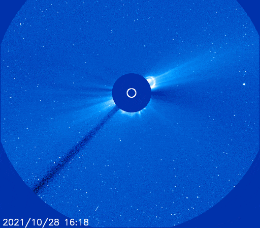
I wrote about Carrington events here, just a few days before the solar cycle 23 unleashed some strong storm with an X1 flare the 28th October and several other CMEs the next days… Fortunately, the impact on earth was minimal: It was a mostly a miss. But it sparked some wonderful display of aurora in the last days of October. See here and here for some nice images.
Still, the storm had an impact in the sky, more precisely, on the satellites in orbit that had either some unwanted reboot, or even in some case, thrusters being spontaneously triggered. One can imagine the damages this can cost.
I have found this paper from 2020 called Flying Through Uncertainty from Thomas Berger and his team discussing the effect of space weather on the uncertainty of the position of satellites in Low Earth Orbit. It actually had some information I did not know before and I wanted to share this here.
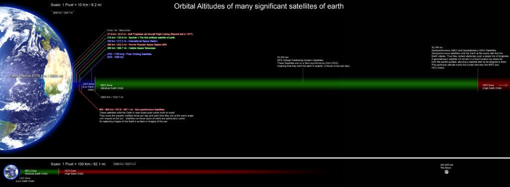
So first of all, what is Low Earth Orbit? Low Earth Orbit (shorten usually by LEO) is the name given for any orbit below 2000 km from earth’s surface. If someone is talking about satellites, chances are that they orbit in that area, bare from geostationary satellites and other specific purpose satellites. One interesting thing is that any object flying with an orbit between 100 km and 1000 km above the earth surface flies in the atmosphere, more or less dense. These layers are called thermosphere and exosphere. Just for a reminder, the ISS flies at approximately 300 km of altitude, straight inside the thermosphere
According to the paper, the problem is that during a geomagnetic storm, the thermospheric density is perturbed in complex ways. Normally, when the space weather is “fair”, the layers of the thermosphere and exosphere are relatively unmoved. The thermosphere gets heated by several processes: UV light from the sun, direct energy transfer via particle collisions, and Joule heating from the electricity produced by the varying solar wind. The temperature of the thermosphere can rise from 200°C to 1500°C. Although, these temperatures are purely in the thermodynamical sense. The gas molecules are so far apart that these temperatures don’t mean the same as on ground level.
When there is some solar unrest, solar wind peaks up, increasing the Joule heating effect that eventually becomes the predominant source of heat. There are also more particle collisions from Coronal Mass Ejections. These create strong perturbations in the thermospheric density.
These variations of the of the thermospheric density have big effects on the satellites flying through the thermosphere, making them slow down or accelerate. The problem is that satellites path are pre-determined, we assume that they will pass above some point at some time, based on some clever calculations. But those calculations do not take into account the variation of speed caused by the variations of the thermospheric density, because those are unknown and random.
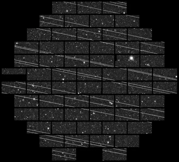
The US Air Force (USAF) tracks all the objects in the sky larger than 10 cm with radar and establish a catalogue of all the objects in orbit. When an interception is possible, the USAF 18th Space Control Squadron (SPCS) issues a collision warning. This is useful mostly if some objects become at risk of interception and prevent it from happening by having one of them move away to clear the path.
During the last notable geomagnetic storm in October 2003, the effects on the thermospheric density were so strong that some LEO satellites were effectively lost for several days, before they were found again after much searching in the sky, appearing kilometres away from their expected positions.
Fortunately, in 2003, there were no reported collisions. But with the recent launch since 2010 of new mega-constellations of satellites such as the much talked about Starlink, this could soon be different. Nowadays, the SPCS issues up to 35000 collision warning per day! This is what a crowded sky looks like and what the future of space expeditions will have to deal with if nothing is done against this problem soon. The next strong geomagnetic storm is going to scramble our view of the LEO objects, who’s where, and costly collisions could happen. It’s time someone deals with this problem one way or another.
Not to mention the awful impact of the Starlink mega-constellation satellites on astrophotography…
Sources
https://spaceweather.com/archive.php?day=29&month=10&year=2021&view=view
https://spaceweathergallery.com/indiv_upload.php?upload_id=179075
https://spaceweathergallery.com/indiv_upload.php?upload_id=179135
https://doi.org/10.1029/2019SW002373
https://commons.wikimedia.org/wiki/File:Orbitalaltitudes.jpg